13 Rocks You Won't Believe Aren't Man-Made!
Advertisement
12. Chiricahua National Monument
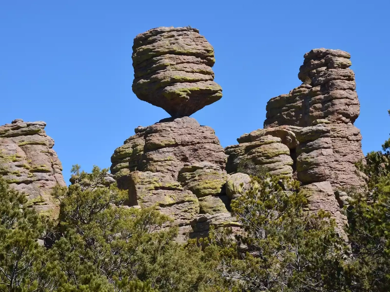
Southeast Arizona's Chiricahua National Monument provides evidence of the raw force of volcanic activity and the patient artistic ability of erosion. Often referred to as a "Wonderland of Rocks," this breathtaking scene sprang from a catastrophic volcanic explosion some 27 million years ago. One of the most large-scale eruptions in American Southwest geological history, this one covered an area roughly 1,200 square miles with a thick covering of pumice and ashes.
Chiricahua's unique terrain was produced from the Turkey Creek Caldera, a large volcanic crater north of the current monument. An large amount of pumice and ash was thrown by this eruption, which over time settled and compressed to create a rock type called rhyolitic tuff. In some areas reaching depths of up to 2,000 feet, this tuff layer became the canvas upon which nature would create her masterwork over millions of years.
A complicated interaction of several elements shapes the erosion process that turned this homogeneous layer of volcanic tuff into the strange scene we observe now. The main sculptor has been water—rain and snow in particular. Water slowly widens these gaps in the rock as it seeps into cracks and crevices using a mix of physical and chemical degradation. Freeze-thaw cycles hasten this process even more since water expands when it freezes, stressing the nearby rock and breaking and separating it.
Furthermore quite important in forming the Chiricahua scenery is wind. It contains abrasive particles that gradually erode the rock surfaces, helping to create the unique qualities of the location. Towering spires, balanced rocks, and the park's well-known "hoodoos"—tall, thin spires of rock rising dramatically from the ground—have been produced by the differential erosion of the volcanic tuff, whereby softer areas erode more rapidly than harder ones.
Among the most recognizable elements of Chiricahua National Monument are the many balanced rocks. Under a tougher capstone, erosion wears away softer rock, producing these precarious-looking formations that seem to be a boulder softly perched atop a little pedestal. Although they seem unstable, many of these balanced rocks have been in place for thousands of years, evidence of the slow rate of geological change under desert conditions.
President Calvin Coolidge named the monument in 1924 to protect these unusual geological formations. But its importance transcends geology as well. The area boasts a rich cultural legacy having housed several Native American tribes, including the Chiricahua Apache, for whom the monument is named. During their fights with European immigrants in the 19th century, the Apache made use of the natural defenses the tough terrain offered.
Chiricahua National Monument is rather unknown among other national parks and monuments in the Southwest despite its amazing beauty and geological importance. With only over 60,000 tourists annually, its far-off position in southeast Arizona, some 120 miles southeast of Tucson, helps to explain its reduced visitor count. This relative remoteness has helped to maintain the landscape's unspoiled beauty and gives guests, in more crowded parks, a sense of serenity and closeness to nature that can be difficult to obtain.
The monument has a range of hiking paths that let guests close-up view its distinctive geological characteristics. For those unable of hiking, the eight-mile Bonita Canyon Drive offers access to scenic views that highlight the dramatic landscapes of the monument. The Heart of Rocks Loop, for example, transports hikers through a wonderland of oddly shaped rock formations including well-known features like "Duck on a Rock" and "Thor's Hammer."
Geologically speaking, Chiricahua National Monument is a valuable location providing information on volcanic processes, erosion trends, and long-term landscape change in arid surroundings. It also is very important in maintaining the special environment of the "sky islands," isolated mountain ranges in southeast Arizona with a wide variety of plant and animal life.
Places like Chiricahua National Monument become increasingly important as climate change keeps affecting the American Southwest. They provide natural venues for researching how variations in temperature and precipitation pattern affect dry environments and ecosystems. The preservation of this special geological and biological treasure guarantees that other generations will be able to wonder at the beauty of the planet and acquire understanding of its dynamic geological processes.
Advertisement
Recommended Reading:
10 Items You Should Never Put Down the Drain →
You are viewing page 12 of this article. Please continue to page 13
Stay Updated
Actionable growth insights, once a week. No fluff, no spam—unsubscribe anytime.
Advertisement
You May Like

Hilarious Road Mishaps: A Collection of Traffic Blunders
09/04/2025

Fisherman Lands Giant Fish And Uncovers A Strange Secret
10/08/2025

Nightly Honey Before Bed: How It Can Affect Your Body
11/01/2025

Cats Being Hilariously Funny Without Even Trying
10/16/2025

20 Short Haircuts That Will Define Your Signature Style
10/14/2025

9 Tender Animal Pictures That Invite a Hug
09/22/2025

Witness 8 Animals Moments Before They Give Birth
09/03/2025

Must Read Masterpiece: The Eternal Book Of All
09/16/2025

Onion Socks: Her Bizarre Nightly Ritual You’ll Want to Try
10/07/2025
These Animal Photos Will Instantly Make You Smile
09/22/2025
Animals Clearly Running the Show in These Hilarious Photos
09/01/2025

Photos That Change How You See World History
09/22/2025

7 Incredible Upside-Down Houses Across the Globe
10/22/2025

20 Ultra-Rare Dog Breeds You've Probably Never Seen
10/03/2025

Two Bananas Daily: Unexpected Health Benefits & Hidden Risks
10/21/2025

20 Loyal Dog Breeds That Protect You Fearlessly
10/06/2025

8 Fascinating Animal Pregnancy Before and After Changes
11/04/2025

Amazing Celebrity Tattoos You Have To See
09/23/2025

The Do’s And Don’ts Of Bringing Your Dog To Work
10/22/2025

Eating 2 Bananas Daily Does This To Your Body
09/04/2025

Unveil the 15 Priciest Dog Breeds on Earth
09/06/2025
What Amazing Things Happen When You Eat Avocado Daily?
10/22/2025

Eating 2 Bananas Daily: The Surprising Health Effects
08/16/2025
Laugh Out Loud: Funny Animal Moments to Make Your Day Better!
10/04/2025
Comments
CipherScholar · 08/15/2025
Helpful negative space usage.
QuantumFable · 09/11/2025
Subtle but impactful.